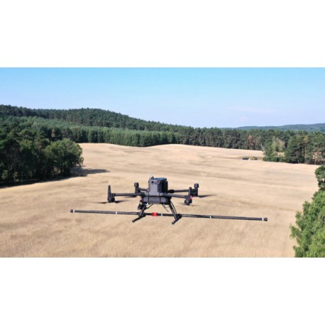
Drone Magnetometer Survey Kit MAGDRONE
R439080
The MagDrone R4 is an ultra light weight magnetometer survey kit with 5 triaxial Fluxgates to be attached to any UAV with a 1,500 g payload.
• 3-axis probes
• Integrated GPS
• Weight : 1.5 kg
Download
More info
The MagDrone R4 is an ultra light weight magnetometer survey kit with 5 triaxial Fluxgates to be attached to any UAV with a 1,500 g payload.
Its dismountable sensor tube allows for sensor spacing of either 25cm or 50cm providing a 2.5m swath width. With 200Hz sampling rate, the R4 can easily filter out noise from infrastructure, net frequencies or UAV motors. Hence, it can be directly installed on UAV’s landing gear for a very compact setup.
The MagDrone R4 can be used for i.e. magnetic cartographies, mine exploration (iron ore mines), area scanning for bombs and ammunition (UXO), preventive check and surveillance of areas against vehicles’ intrusion.
The MagDrone Data Tool identifies flown tracks, cut, filter, compensate the raw data, generates a preview and exports into various formats to further process the recorded values, i.e. with our MAGNETO® software.
TECHNICAL DATA
General Technical Data
Power Supply : 12-32 V
Operating Temperature : -20°C to +50°C
Weight : 1,500 g
Overall power consumption : 10 W
Sensor tube dimensions (L x D) : 2,074 x 29 mm
FGM3D/75 Fluxgate
Sensors : 5 sensors, laid horizontal, parallel
Specified measurement range : ±75,000 nT
Number of sensor axis : 3
Distance between sensors : 500 mm
Noise level @1Hz [pT/ (Hz)] : 10 pT<all sensors M1-M5<20 pT
Datalogger
Power : 50 mA
Sensor input : Hard wired, 75cm sensor cable
User Interface : Start/Stop button; Webserver
Survey mode : Continuous recording while airborne
Sampling rate : 200 Hz (higher rates available on request)
Internal memory : 8 GB (approx. 120h recording)
Datalogger dimensions : 264,5 x 104,5 x 80 mm
Data Processing
MagDrone DataTool (included) : Raw data filtering, track &
flight direction detection, noise compensation, MagBase or
GPS referencing, export, preview
MAGNETO® Software : Data interpretation, visualization,
object calculation, etc.
Live output Via Webserver


 Download (266.9k)